site title

HOME PROTECTION NATURE PLAN YOUR VISIT FAQ JOIN/DONATE ABOUT
DOIN' THE DOUG - PLAN YOUR VISIT

Visitor Guide
Coming soon, an updated version. Watch this space
plan visit map thumbnail graphic
Click on the image to download a pdf of the guide


mt jefferson russell lake winter graphic
Go to the Special Places page
Photo courtesy of Darryl Lloyd

panorama point small graphic
Menagerie Wilderness from Panorama Point
Photo by David Tvedt

PAVED ROAD TOURING IN THE DOUG
quartzville sign graphic autotouring thumbnail graphic bike graphic
HIKING THE DOUG: TRAILS GUIDE and TRAILS INDEX AND MAP
meadow trail thumbnail graphic trail in forest thumbnail graphic hackleman map thumbnail graphic
RIVERS
middle santiam thumbnail graphic quartzville river thumbnail graphic middle santiam falls thumbnail graphic
EXPLORING WILDFLOWERS
trillium thumbnail graphic fireworks flower thumbnail graphic purple flowers thumbnail graphic
LOOKING FOR BIRDS
bald eagle thumbnail graphic varied thrush 6 thumbnail graphic bluebird thumbnail graphic
LOOKING FOR TREES IN THE FORESTS
forest tall trees thumbnail graphic mountain view thumbnail graphic forest view distant thumbnail graphic
CAMPGROUNDS AND OTHER PLACES TO STAY
yellowbottom campground thumbnail graphic dispersed camping thumbnail graphic breitenbush sign thumbnail graphic

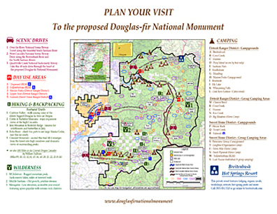
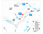
Be careful / Be safe:  Douglas-Fir National Monument is wonderfully wild, especially off the paved roads. Be sure you and your vehicle are capable of safely traveling the gravel and other back-country roads. They can be rough, narrow, and steep. Some roads are closed in winter or not maintained in winter. Get a free US Forest Service Motor Vehicle Use map for the Detroit & Sweet Home Districts at any District offce in the Willamette National Forest and stay on designated roads. Use a paper map, GPS and Cell phone service can be unreliable. Medical help is far away.

Friends of Douglas-Fir National Monument is not responsible for your safety, YOU ARE