|
|
| HOME | PROTECTION | NATURE | PLAN YOUR VISIT | FAQ | JOIN/DONATE | ABOUT |
| DOIN' THE DOUG - TRAIL GUIDES |
|
Whitewater Trail to Jefferson
Park
|
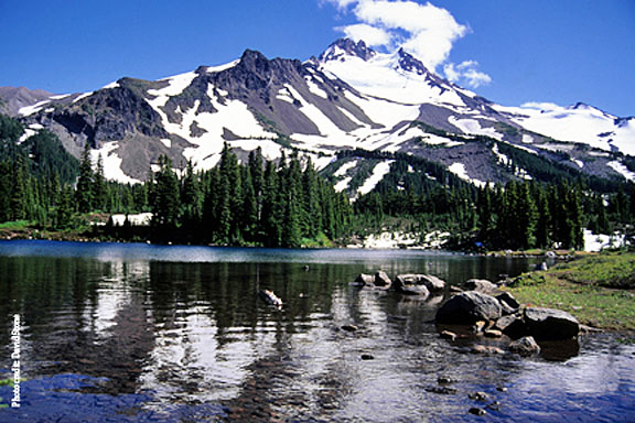 Jefferson Park |
| Length: 11.6 miles along the Whitewater Trail
connecting to the Pacific Crest Trail (PCT) to Russell Lake,
one way. 4.2 miles from trailhead to the PCT Difficulty: Difficult 1800 feet elevation gain [WS 22] FS trail #3429: (titled) Whitewater Trail A special permit is required for this trail, effective May 2021. Information |
| The Jefferson Park area within the Mt. Jefferson Wilderness is an
incredibly popular destination, providing iconic views of Mt.
Jefferson, alpine lakes and abundant wildflowers. To avoid
crowded conditions, try going during the week. Backpacking, day hiking and mountaineering are the most common forms of recreation in the area during the short summer season. Opportunities for nature photography also abound. Mt. Jefferson and Park Ridge are the dominant features of the Jefferson Park area. Mt. Jefferson's slopes are mantled by five glaciers: Whitewater, Waldo, Milk Creek, Russell and Jefferson Park. Jefferson Park proper consists of sensitive subalpine meadows and lakes with an extremely short growing season. Vegetation is dwarfed with old-growth mountain hemlock the size of most 10-20 year old conifers. Other geographic features include steep talus slopes, rock outcrops and alpine meadows. Visitors should obtain a detailed topographical map of the area before planning a trip, and inquire in advance about trail conditions, particularly early in the season. Jefferson Park can hold substantial snow well into June/July on an average snow year, so plan your trip accordingly. The Whitewater Trail is one of several ways to reach Jefferson Park in the Mt. Jefferson Wilderness. The trail begins to gain elevation quickly from the parking area, climbing through large Douglas-Fir, Western Hemlock forest with a few Pacific Yew and Western White Pine interspersed. At 1.5 miles the trail intersects with the Triangulation Trail (#3373), which leads to Triangulation Peak. Turn right to stay on the Whitewater Trail. At around 3 miles your climb pays off with views of Mt. Jefferson. At four miles you will reach the crossing of Whitewater Creek, which has no bridge. Depending on water levels this can be a difficult crossing. The trail joins the Pacific Crest Trail (PCT) just past mile 4. Keep left at PCT, which crosses one or two small creeks and a few small meadows leading north to access Jefferson Park.  Trailhead directions: From Salem drive 61 miles east, from Detroit, OR travel about 10 miles southeast, on North Santiam Highway 22. Turn left on Forest Road 2243 (Whitewater Road). Travel the gravel road about 7.5 miles to the trailhead and parking area. There is room for 25 vehicles and a restroom. |