|
|
| HOME | PROTECTION | NATURE | PLAN YOUR VISIT | FAQ | JOIN/DONATE | ABOUT |
| DOIN' THE DOUG - TRAIL GUIDES |
|
Chimney Peak Trail Alternative
Access
|
| Length: Approximately 11 miles (SHRD) Difficulty: Difficult Elevation Change: approximately 2,300 feet. Forest Service Trail #3382 Site: Chimney Peak NOTE: this trail goes into the Middle Santiam Wilderness (permit required). |
| This is an alternative to the access to the Chimney
Peak Trail that uses Spur Road 646 to reach the trailhead.
This alternative connects to the Chimney Peak Trail at a mid point
by staying on Forest Road 2041, past the spur road (646) for an
additional 3 miles to the road closure (shown on the map below by
the designation "Road Closed." Hike along the road past the closure
point for 3 miles to what was the original trailhead. This route
shortens the total hike by approximately 2 miles (round trip) and
bypasses the need to wade the Middle Santiam. The road bridge across
Pyramid Creek was damaged, so wading is necessary. The trail along the closed road skirts the wilderness boundary until it reaches the Chimney Peak Trail crossing the road. When you reach the trail itself, turn left and you will soon enter the Middle Santiam Wilderness and reaching Donaca Lake. Beyond Donaca Lake, through the heart of the wilderness, the trail gradually gains elevation to the base of Chimney Peak. There used to be a fire lookout at the top of the peak. It is a challenging climb up the peak to the former lookout site. BE CAREFUL. 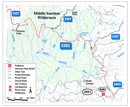 |
Directions: From Sweet Home Ranger District office in Sweet Home: travel east on Highway 20 for 23.1 miles (Highway mile 52.5) turn left on forest Road 2041 (Soda Fork Road). Stay on 2014 for 12 miles to spur road 646. Continue past the spur until you reach a T on Road 2041. Turn right and proceed until you reach the road closure, a total of 3 miles past the Spur Road 646. Forest Road 2041 road is passable by any vehicle, although the roadbed is rough, at least to the Spur 646. There are a number of junctions, most of which are marked. If you choose the road that seems the most traveled, you should be alright. Road 2041 passes through private land as well as Forest Service land, clear cuts, recently planted sectors, and thinned middle aged second growth forests. Drive carefully, in the right season there are log trucks on the road. |