|
|
| HOME | PROTECTION | NATURE | PLAN YOUR VISIT | FAQ | JOIN/DONATE | ABOUT |
| DOIN' THE DOUG - TRAIL GUIDES |
|
Trout Creek Trail
|
| Length: 2.8 miles Difficulty: Moderate / Difficult Elevation Gain: 1,300 - 3,567 feet William Sullivan Trail Number [112 (Rooster Rock)] This trail goes into the Menagerie Wilderness (permit required) Forest Service Trail #3405 Site: Trout Creek Trail |
| This smoothly graded trail takes you through a 100-year old
forest, regenerated from a large burn. The top of Rooster Rock comes
into view as you climb, as do views across the South Santiam River
valley. The trail joins the shorter, steeper Rooster Rock Trail about a half mile from the top. William Sullivan says about the trail after joining Rooster Rock Trail: "when the trail forks, ignore the route straight ahead - it's a rough climbers trail to a logging road near Rabbit Ears' twin 260 foot pillars. Take the right hand fork, to a rock knoll that was the base camp for a fire lookout perched atop Rooster Rock's pinnacle." 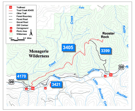 |
| Directions: From Sweet Home Ranger District office in Sweet Home: travel east on Highway 20 for 19.4 miles (Highway mile 48.8). The trailhead is on the left, across the highway from, and just east of the entrance to Trout Creek Campground.) All miles are approximate, yours may vary. |